-40%
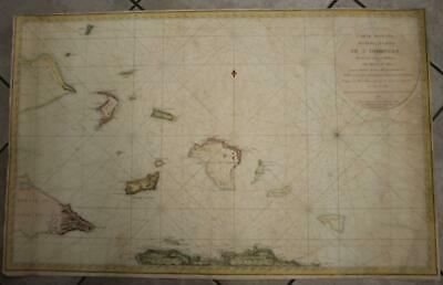
TURKS & CAICOS ISLANDS BAHAMAS CUBA 1787 DÉPÔT MARINE VERY LARGE ANTIQUE CHART
$ 32.2
- Description
- Size Guide
Description
TURKS & CAICOS ISLANDS BAHAMAS CUBA 1787 DÉPÔT MARINE VERY LARGE ANTIQUE CHARTTURKS & CAICOS ISLANDS BAHAMAS CUBA 1787 DÉPÔT MARINE VERY LARGE ANTIQUE CHART
Description
Carte Réduite des débouquemens de St. Domingue Levée, Dressée et Publiée par ordre du Roi Sous le Ministere de Mr. le M.al de Castries, Ministre et Secretaire d'Etat ayant le département de la Marine D'après les Observations faites sur la Corvette de Vautour en 1784 et 1785 Par M. le C.te de Chastenet-Puisegue Major des V.aux du Roi de l'Académie de Marine. 1787.
Description:
Striking and highly detailed fine large-format 1787 Dépôt de la Marine
's
attractive original copper engraved sea chart or nautical map
centered on the Turks & Caicos Islands and the Southern Islands of the Bahamas.
Fine, large-scale chart covers Hispaniola, Turks & Caicos Islands, Lower Bahamas, and the eastern end part of Cuba.
Extends north to Rum Cay, San Salvador Island and the southern part of Long Island. Crooked Island, the Inagua Islands, the Plana Cays and Mayaguana are all shown
.
A simple title cartouche and a fleur-de-lis radiating rhumb lines complete the map
.
Date:
1787 ( dated )
Dimension:
Paper size approx.:
cm 92,8Â x 58,8
Condition:
Very strong and dark impression on good paper. Paper with chains. Map contemporary handcolored. Margin to the top cut very shortly. Small lower margin. Short lateral margins. Lower right corner partially missing, redone and hanwritten, as you can see in the images. Small foxing. Map professionally washed and restored. Conditions are as you can see in the images
.
Cartographers:
The Dépôt de la Marine, known more formally as the Dépôt des cartes et plans de la Marine, was the central charting institution of France. The centralization of hydrography in France began in earnest when Jean-Baptiste Colbert became First Minister of France in 1661. Under his watch, the first Royal School of Hydrography began operating, as did the first survey of France’s coasts (1670-1689). In 1680, Colbert consolidated various collections of charts and memoirs into a single assemblage, forming the core of sources for what would become the Dépôt.
The DĂ©pĂ´t itself began as the central deposit of charts for the French Navy. In 1720, the Navy consolidated its collection with those government materials covering the colonies, creating a single large repository of navigation. By 1737, the DĂ©pĂ´t was creating its own original charts and, from 1750, they participated in scientific expeditions to determine the accurate calculation of longitude.
In 1773, the Dépôt received a monopoly over the composition, production, and distribution of navigational materials, solidifying their place as the main producer of geographic knowledge in France. Dépôt-approved charts were distributed to official warehouses in port cities and sold by authorized merchants. The charts were of the highest quality, as many of France’s premier mapmakers worked at the Dépôt in the eighteenth century, including Philippe Bauche, Jacques-Nicolas Bellin, Rigobert Bonne, Jean Nicolas Buache, and Charles-François Beautemps-Beaupré.
The Dépôt continued to operate until 1886, when it became the Naval Hydrographic Service. In 1971, it changed names again, this time to the Naval and Oceanographic Service (SHOM). Although its name has changed, its purpose is largely the same, to provide high quality cartographic and scientific information to the France’s Navy and merchant marine.
All of the maps we sell are ORIGINALS. We guarantee all of our maps to be authentic. We do our best to describe the condition of our maps as accurately as possible. Due to the age and type of paper, some imperfections are to be expected. Please examine the images provided carefully, and if you have any questions please ask and we will be happy to help.
A Certification of Authenticity ( COA ) can be issued on request
I will send you all your item by Registered and Insured Airmal or by TNT/DHL with covering Insurance
If you buy more than one item you have to pay just one only shipping cost
Any map purchased from us may be returend for any reason for a full refund.
About:
Old Times
Rare Antiquarian Books & Maps Sellers
Our Firm was founded in 1983 and we are specialized on antiquarian works on paper concerning Antique Rare Maps, Atlases and Travel Books of all the World.
Our Firm adheres to the Codes of Ethics outlined by the Italian Antiquarian Booksellers Association ( ALAI ) and International League of Antiquarian Booksellers ( ILAB ).
All items sold by OLD TIMES are genuine and a Certificate of Authenticity (COA) will be happily supplied on request.
Many Thanks
Cesare Giannelli
OLD TIMES
RARE ANTIQUARIAN BOOKS & MAPS SELLERS
Via Cortonese, 70
06124 - Perugia
Italy
Phone/Fax:Â 0039 - 075 - 505 20 18
http://www.oldtimesrarebooks.com
View My Feedback
View My Other Items For Sale
View My About Me page
Visit My eBay Store
Add me to your Favorite Sellers
Click images to enlarge
Images sell!
Get Supersized Images & Free Image Hosting
Create your brand with Auctiva's
Customizable Templates.
Attention Sellers - Get Templates
Image Hosting, Scheduling at Auctiva.com.
Track Page Views With
Auctiva's FREE Counter
