-40%
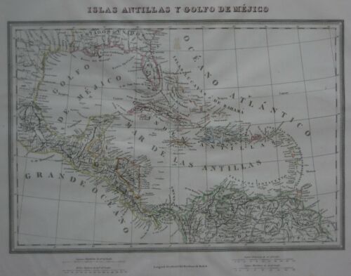
Original 1835 Spanish Map FLORIDA WEST INDIES Cuba Puerto Rico Panama Venezuela
$ 168.95
- Description
- Size Guide
Description
Original 1835 Spanish Map FLORIDA WEST INDIES Cuba Puerto Rico Panama VenezuelaOriginal antique hand colored engraved map of the West Indies and Central America, including part of the southeast United States and northwest South America, printed more than 180 years ago.
This map is titled
Islas Antillas y Golfo de Méjico,
and the image area measures 26.7 x 38.4 cm [10½" x 15"]. Longitude is measured from Madrid, and there are four distance scales in the lower margin.
The coverage area extends from Charleston, South Carolina to the Corentin River in the Guianas, west to San Luis Potosi, Mexico, including present-day Florida, Cuba, Puerto Rico, Bahamas, Belize, Costa Rica, El Salvador, Guatemala, Honduras, Nicaragua, Panama, parts of Venezuela and Colombia, as well as Haiti,the Dominican Republic, Trinidad, Jamaica, Martinigue, Guadeloupe, and all the other islands of the Caribbean.
This map was published in Barcelona, Spain by José Torner. It was issued in an atlas titled
Colección de mapas geográficos antiguos y modernos del acreditado Tardieu y otros autores clásicos...
, compiled and engraved by Domingo Estruc, Pablo Alabern and Ramon Alabern (son of Pablo).
It was printed circa 1835 and it is interesting to note that it does not reflect the changes that had taken place in New Spain over the dozen or years prior to that. The map locates San Antonio but does not name Texas, which is shown as part of Mexico. Colombia is labeled "Nueva Granada," Venezuela is "Caracas," Panama is "Terre Firme," and Central America is "Nueva España." A large part of Honduras is labeled "Mosquito."
Condition:
This map is in very good condition, bright and clean, with
no
rips or tears. There are generous margins on all sides and a vertical center fold, as issued. It is blank on the back, with no printing on the reverse side. Please see the scans, which include front and back views of the full sheet, and feel free to ask any questions.
This is an
authentic antique map
, with original outline coloring,
not
a reproduction or modern reprint, and it is fully guaranteed to be genuine.
It would make a handsome display in your den or office. It would also make a perfect gife, and we'll include our helpful framing tips with your purchase. We are pleased to offer this map with
our unconditional, money-back guarantee.
Powered by SixBit's eCommerce Solution


