-40%
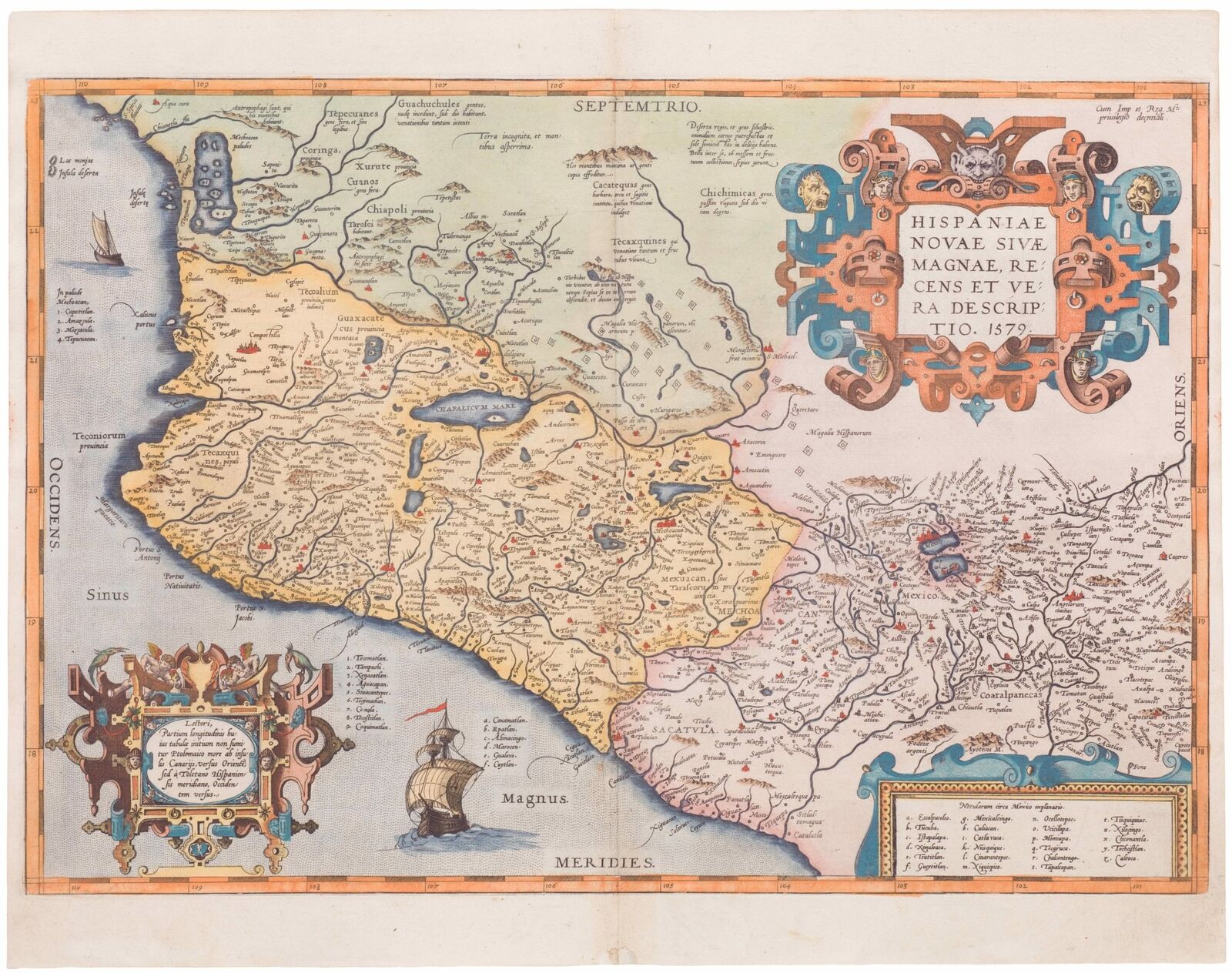
Hispaniae novae sive magnae recens et vera descriptio
$ 514.79
- Description
- Size Guide
Description
Ortelius's map of Mexico, one of the earliest printed maps ofNew Spain
.
Title:
Hispaniae novae sive magnae recens et vera descriptio
Identifier:
NL-00246
WE SELL ONLY ORIGINAL ANTIQUE MAPS -- NO REPRODUCTIONS
Description
This was the standard map of the area for a generation, copied by De Bry, Quad, and Hondius. Even though Herrera (Spain's Royal Cosmographer) and Wytfliet worked twenty years after Ortelius, they produced inferior maps of the to this one. The map shows an area corresponding roughly to the modern Mexican states of Michoacan, Jalisco, Mayarit, and Guerrero, plus the Valley of Mexico.
It is adorned with two strapwork cartouches and sailing ships. Note the large number of place names, often so densely distributed that reference by number or letter is used to save space, and lines are drawn from place names to circles indicating their location. Numerous rivers are depicted, but most of them remain unnamed. Spanish barracks or tents are indicated by small squares with a circle in the middle.
Verso Text: Latin
Condition description:
A good and dark impression with vivd colors.
Dimensions:
51 x 35 cm (20 x 13.7 in)
Shipping
FedEx Ground or Home Delivery (25 USD): USA Only. 1 - 10 days. If your address is a P.O. Box and cannot ship FedEx we will ship USPS Priority and, while we ship promptly, recent postal personnel cutbacks mean that delivery may take time. Signature Required.
FedEx International or DHL International EXPRESS (45 USD)
Payments
We accept the following payment methods:
Paypal
Visa
Please contact us if you have any questions
Terms of service
Customs:
International buyers are responsible for paying duty and taxes on delivery. DHL or FedEx will contact the buyer by telephone to arrange tax payment if it is levied. Duty varies by country and we cannot predict the amount you will be charged. Some countries are duty free, others are not. Typically, a customs duty and/or VAT tax will be assessed on all parcels to continental Europe. Sometimes duty or tax is due in China, but is seems very random. Hong Kong, Singapore, Korea, and Taiwan have never assessed duty on a map we shipped. Maps shipped to the UK should be duty free as educational materials, but from time to time duty of 5% is assessed incorrectly by the UK customs agents.
Insurance:
All shipments are insured privately against loss and damage. All of our shipments require a signature for insurance purposes.
If you have any questions please feel free to email us through eBay. BEWARE anyone attempting to contact you, from a different eBay account, claiming to represent Neatline Antique Maps. My eBay handle is NeatlineMaps. If you are contacted by email by someone offering you my items, please call me directly to be certain you are not dealing with a con artist.


