-40%
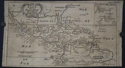
CENTRAL AMERICA SOUTHERN UNITED STATES MEXICO 1712 DAMPIER UNUSUAL ANTIQUE MAP
$ 16.36
- Description
- Size Guide
Description
CENTRAL AMERICA SOUTHERN UNITED STATES MEXICO 1712 DAMPIER UNUSUAL ANTIQUE MAPCENTRAL AMERICA SOUTHERN UNITED STATES MEXICO 1712 DAMPIER UNUSUAL ANTIQUE MAP
Description
Carte de la Partie du Milieu de l'Amerique.
Description:
Striking and highly detailed
interesting 1712 William Dampier's copper engraved map depicting
part of the route of Dampier's first circumnavigation voyage in the 1680s with his passage across the isthmus of Panama. The map covers the area of northern South America through Central America into what is now the southern United States with Maryland, Virginia, Carolina, Florida, and New Mexico named. There is an inset map detailing the Cape Verde islands with the route of exploration delineated. On the map, California is an island although only the southern portion is shown.
Source:
William Dampier. Voyage de Guillaume Dampier aux Terres Australes, à la Nouvelle Hollande, &c. A Amsterdam: Chez la Veuve de paul Marret, MDCCXII (1712)
.
Date:
1712 ( undated )
Dimension:
Paper size approx.:
cm 28,8 x 15,8
Condition:
Very strong and dark impression on good paper. Paper with chains. Map uncolored. Margin to the top missing. Lower margin missing
. Short right lateral margin. Left lateral margin cut shortly. Paper with foxing and browning. Map folded. Conditions are as you can see in the images
.
Mapmakers:
William Dampier (baptised 5 September 1651; died March 1715) was an English explorer, pirate, privateer, navigator, and naturalist who became the first Englishman to explore parts of what is today Australia, and the first person to circumnavigate the world three times. He has also been described as Australia's first natural historian, as well as one of the most important British explorers of the period between Francis Drake (16th century) and James Cook (18th century), he "bridged those two eras" with a mix of piratical derring-do of the former and scientific inquiry of the later. His expeditions were the among first to identify and name a number of plants, animals, foods, and cooking techniques for a European audience; being among the first English writers to use words such as avocado, barbecue, and chopsticks. In describing the preparation of avocados, he was the first European to describe the making of guacamole, named the breadfruit plant, and made frequent documentation of the taste of numerous foods foreign to the European palate such as flamingo and manatee.
After impressing the Admiralty with his book A New Voyage Round the World, Dampier was given command of a Royal Navy ship and made important discoveries in western Australia, before being court-martialled for cruelty. On a later voyage he rescued Alexander Selkirk, a former crewmate who may have inspired Daniel Defoe's Robinson Crusoe. Others influenced by Dampier include James Cook, Horatio Nelson, Charles Darwin, and Alfred Russel Wallace.
All of the maps we sell are ORIGINALS. We guarantee all of our maps to be authentic. We do our best to describe the condition of our maps as accurately as possible. Due to the age and type of paper, some imperfections are to be expected. Please examine the images provided carefully, and if you have any questions please ask and we will be happy to help.
A Certification of Authenticity ( COA ) can be issued on request
I will send you all your item by Registered and Insured Airmal or by TNT/DHL with covering Insurance
If you buy more than one item you have to pay just one only shipping cost
Any map purchased from us may be returend for any reason for a full refund.
About:
Old Times
Rare Antiquarian Books & Maps Sellers
Our Firm was founded in 1983 and we are specialized on antiquarian works on paper concerning Antique Rare Maps, Atlases and Travel Books of all the World.
Our Firm adheres to the Codes of Ethics outlined by the Italian Antiquarian Booksellers Association ( ALAI ) and International League of Antiquarian Booksellers ( ILAB ).
All items sold by OLD TIMES are genuine and a Certificate of Authenticity (COA) will be happily supplied on request.
Many Thanks
Cesare Giannelli
OLD TIMES
RARE ANTIQUARIAN BOOKS & MAPS SELLERS
Via Cortonese, 70
06124 - Perugia
Italy
Phone/Fax: 0039 - 075 - 505 20 18
http://www.oldtimesrarebooks.com
View My Feedback
View My Other Items For Sale
View My About Me page
Visit My eBay Store
Add me to your Favorite Sellers
Click images to enlarge
Get images that
make Supersized seem small.
Showcase your items with Auctiva's
Listing Templates!
THE simple solution for eBay sellers.
Track Page Views With
Auctiva's FREE Counter
