-40%
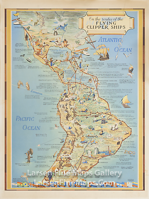
1939 On the Routes of the PAN AM Flying Clipper Ships. Original Poster
$ 352.17
- Description
- Size Guide
Description
1939 On the Routes of the PAN AM Flying Clipper Ships. Original PosterA gorgeous pictorial map from Pan Am Airlines (PAA) showing part of North America, Central America, and South America. The map depicts the routes of the "Flying Clipper Ships" in thick brown lines with dots representing the ports of call. The map is loaded with artistic vignettes showing various local resources, products, points of interest, activities, anecdotes, and other fun information. Text call-outs abound describing all of these things. Flags of the various countries adorn the lower edge of the map.The listing of this map shows some evidence for the provenance of the map. The map was acquired in the custom inlaid Rosewood (or perhaps a type of Walnut) frame by Atelier Elizabeth in Rio de Janeiro in the 1930's and labeled with "Industria Brasileira Atelier Elizabeth, R.D. Gerardo 44, Rio De Janeiro". The padding materials used to fill the void in the framing was found to be a local Rio De Janeiro newspaper dated "18 De Setembro De 1940". It would be quite safe to presume the map was framed in Rio De Janeiro sometime in September, 1940.NOTE: Frame is NOT INCLUDED with the map in this listing. Please contact Larsen Fine Maps Gallery should you be interested in acquiring the frame separately as well.
1939 On the Routes of the PAN AM Flying Clipper Ships. Original Poster
YEAR PUBLISHED:
1939
CARTOGRAPHER/MAPMAKER:
Kenneth W. Thompson
PUBLICATION:
PUBLISHER:
Kenneth W. Thompson
FULL TITLE:
On the Routes of the PAA Flying Clipper Ships
CONDITION:
Very fine condition with very minor edge abrasions and minute tear or two. Some toning and light stains in margins at upper and lower right. Rich color. Verso blank.
DIMENSIONS:
17.5 X 23.5
DESCRIPTION:
A gorgeous pictorial map from Pan Am Airlines (PAA) showing part of North America, Central America, and South America. The map depicts the routes of the "Flying Clipper Ships" in thick brown lines with dots representing the ports of call. The map is loaded with artistic vignettes showing various local resources, products, points of interest, activities, anecdotes, and other fun information. Text call-outs abound describing all of these things. Flags of the various countries adorn the lower edge of the map.
The listing of this map shows some evidence for the provenance of the map. The map was acquired in the custom inlaid Rosewood (or perhaps a type of Walnut) frame by Atelier Elizabeth in Rio de Janeiro in the 1930's and labeled with "Industria Brasileira Atelier Elizabeth, R.D. Gerardo 44, Rio De Janeiro". The padding materials uséd to fill the void in the framing was found to be a local Rio De Janeiro newspaper dated "18 De Setembro De 1940". It would be quite safe to presume the map was framed in Rio De Janeiro sometime in September, 1940.
NOTE:
Frame
is
NOT INCLUDED
with the map in this listing. Please contact Larsen Fine Maps Gallery should you be interested in acquiring the frame separately as well.
×
×
×
×
×
×
Buy now and save!
Tell a friend
Visit store
Watch now
Postage info
Click the Postage tab above the listing description for more info
FREE Postage
Click the Postage tab above the listing description for more info!
Additional delivery notes
PICK UP OPTION
Sorry, our items are NOT available for pick-up.
PAYING VIA PAYPAL
We accept PayPal on our all our items so you can shop with confidence.
Simple choose the PayPal option when proceeding through the checkout.
Additional Information
No additional information at this time
Ask seller a question
You might also like
1951 Vintage Map of Greenfield Village, Thomas A. Edison, Henry Ford
1829 Antique Map of The County of Surrey
1829 Antique Map of The County of Sussex
1880 Antique USGS Progress Map, George Wheeler
Contact
To contact our Customer Service Team, simply click the button here and our Customer Service team will be happy to assist.
Ask seller a question
© Larsen Fine Maps Gallery
Postage
Shipping is FREE for this item
Payment
Accepted Payment Methods
PayPal
Returns
Returns are
not
accepted
Buyer will pay for return shipping.
eBay integration
by


