-40%
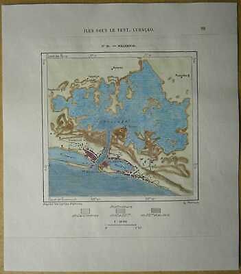
1893 Perron map WILLEMSTAD, CURACAO, NETHERLANDS ANTILLES (#23)
$ 12.13
- Description
- Size Guide
Description
Perron18_0231893 Perron map WILLEMSTAD, CURACAO, NETHERLANDS ANTILLES (#23)
Nice map titled
Willemstad,
from wood engraving with fine detail and clear impression, nice hand coloring. Overall size approx. 19 x 16.5 cm, image size approx. 10 x 10 cm. From
La Nouvelle Géographie universelle, la terre et les hommes
, 19 vol. (1875-94), great work of Elisee Reclus. Cartographer is Charles Perron.
Willemstad
chief town of Curaçao and capital of the Netherlands Antilles in the Caribbean Sea, on the southern coast of Curaçao. It is divided into two parts by the Sint Anna Baai (Saint Anne Bay) leading to Schottegat Harbour. The two halves, Punda and Otrabanda (Other Side), are joined by the Koningin Emma Brug, or Queen Emma Pontoon Bridge, built in 1888. A fixed bridge was completed in 1974.
Willemstad is a Caribbean centre of trade, petroleum storage and refining, tourism, and banking. The town has many Dutch-style gabled houses. Important buildings include Ft. Amsterdam, which once guarded the entrance to Schottegat Harbour and is now the seat of government; the Dutch Reformed Church (1769); and the Mikve Israel Synagogue (1732), the oldest in the Western Hemisphere. There is also an old slave market and the Curaçao Museum. Pop. (1985 est.) 125,000.
