-40%
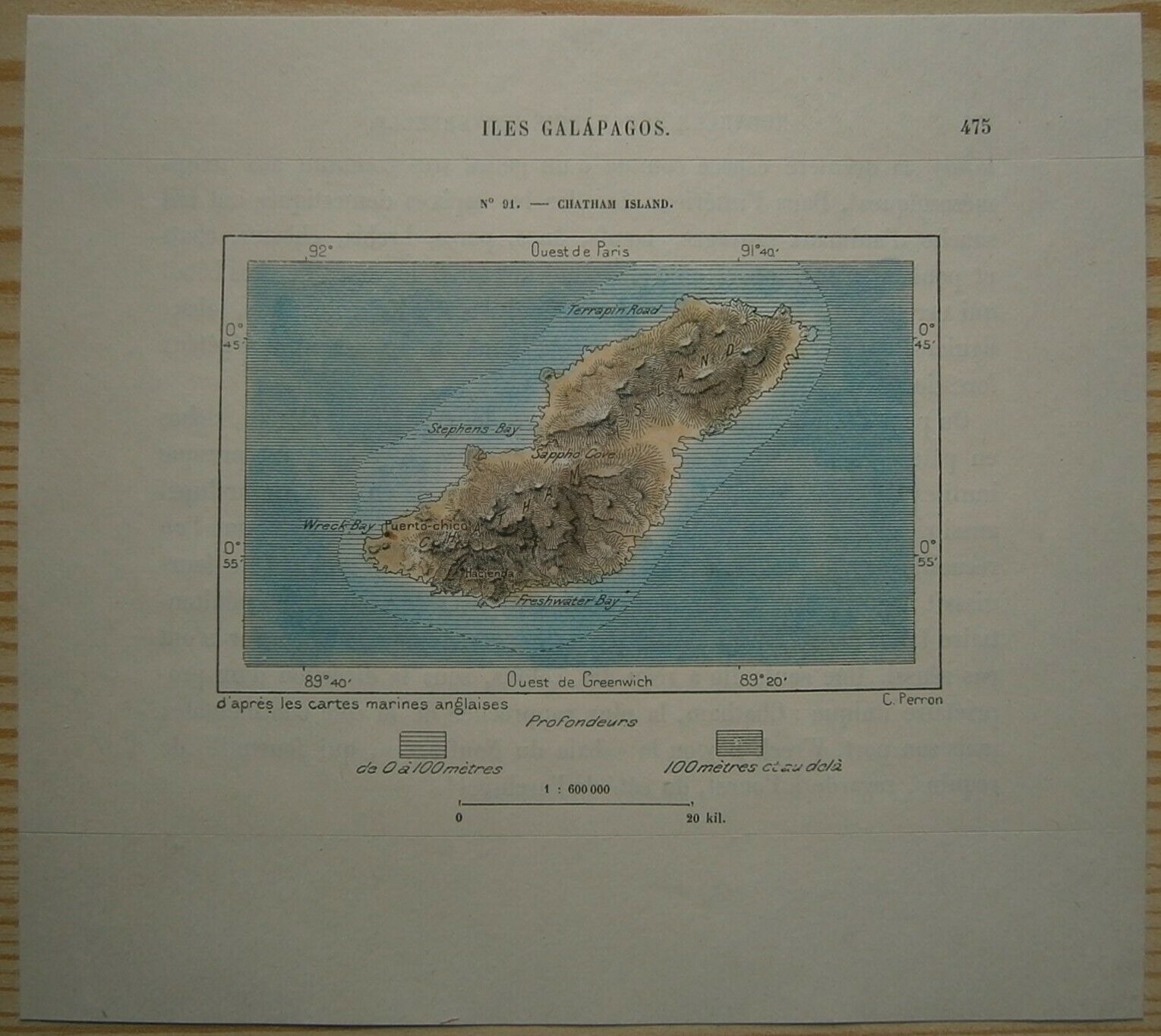
1893 Perron map SAN CRISTOBAL (CHATHAM) ISLAND, GALAPAGOS ISLANDS, ECUADOR (#91)
$ 10.53
- Description
- Size Guide
Description
Perron18_0911893 Perron map SAN CRISTOBAL (CHATHAM) ISLAND, GALAPAGOS ISLANDS, ECUADOR (#91)
Nice small map titled
Chatham Island,
from wood engraving with fine detail and clear impression, nice hand coloring. Overall size approx. 16.5 x 15.5 cm, image size approx. 10.5 x 6.5 cm. From
La Nouvelle Géographie universelle, la terre et les hommes
, 19 vol. (1875-94), great work of Elisee Reclus. Cartographer is Charles Perron.
San Cristóbal Island
Spanish Isla San Cristóbal, also called Chatham Island, one of the easternmost of the Galápagos Islands in the eastern Pacific Ocean. San Cristóbal Island lies approximately 600 miles (965 km) west of Ecuador. It was originally named by English pirates for William Pitt, Earl of Chatham. With an area of 195 square miles (505 square km), San Cristóbal is the most populated and fertile island of the archipelago. Volcanic in origin, with its highest point 2,940 feet (896 m), San Cristóbal is the only island of the Galápagos group that has a regular water supply (from rainwater that gathers in broken craters). The settlements of San Cristóbal (the nominal capital of the Galápagos) and Puerto Baquerizo Moreno are located on Bahía de Naufragio (Wreck Bay). Charles Darwin, the English naturalist, landed at San Cristóbal in 1835 and compiled data that he later incorporated into his Origin of Species. A monument to Darwin was erected in 1935. Formerly a penal colony, Puerto Baquerizo is now an Ecuadoran military base and the export centre for the island's products, including sugar, coffee, cassava, cattle, fish, and lime. Pop. (1980 est.) 2,781.
Galapagos Islands
Spanish Islas Galápagos , officially Archipiélago de Colón (“Columbus Archipelago”)
island group of the eastern Pacific Ocean, administratively a province of Ecuador. The Galapagos consist of 13 major islands (ranging in area from 5.4 to 1,771 square miles [14 to 4,588 square km]), 6 smaller islands, and scores of islets and rocks lying athwart the Equator 600 miles (1,000 km) west of the mainland of Ecuador. Their total land area of 3,093 square miles (8,010 square km) is scattered over 23,000 square miles (59,500 square km) of ocean. The government of Ecuador designated part of the Galapagos a wildlife sanctuary in 1935, and in 1959 the sanctuary became the Galapagos National Park. In 1978 the islands were designated a UNESCO World Heritage site, and in 1986 the Galapagos Marine Resources Reserve was created to protect the surrounding waters. The Charles Darwin Research Station on Santa Cruz (Indefatigable) Island promotes scientific studies and protects the indigenous vegetation and animal life of the Galapagos.
The Galapagos Islands are formed of lava piles and dotted with shield volcanoes, many of which are periodically active. The striking ruggedness of the arid landscape is accentuated by high volcanic mountains, craters, and cliffs. The largest of the islands, Isabela (Albemarle), is approximately 82 miles (132 km) long and constitutes more than half of the total land area of the archipelago; it contains Mount Azul, at 5,541 feet (1,689 metres) the highest point of the Galapagos Islands. The second largest island is Santa Cruz.
The Galapagos Islands were discovered in 1535 by the bishop of Panama, Tomás de Berlanga, whose ship had drifted off course while en route to Peru. He named them Las Encantadas (“The Enchanted”), and in his writings he marveled at the thousands of large galápagos (tortoises) found there. Numerous Spanish voyagers stopped at the islands from the 16th century, and the Galapagos also came to be used by pirates and by whale and seal hunters. The area had been unclaimed for almost 300 years before colonization began on what is now Santa María Island in 1832, when Ecuador took official possession of the archipelago. The islands became internationally famous as a result of their being visited in 1835 by the English naturalist Charles Darwin; their unusual fauna contributed to the groundbreaking theories on natural selection presented in his On the Origin of Species (1859).
The climate of the Galapagos Islands is characterized by low rainfall, low humidity, and relatively low air and water temperatures. The islands have thousands of plant and animal species, of which the vast majority are endemic. The archipelago's arid lowlands are covered by an open cactus forest. A transition zone at higher elevations is covered with a forest in which pisonia (a four o'clock plant) and guava trees dominate, and the moist forest region above the transition zone is dominated by a Scalesia forest with dense underbrush. The treeless upland zone is covered with ferns and grasses.
The archipelago is renowned for its unusual animal life. Its giant tortoises are thought to have some of the longest life spans (up to 150 years) of any creature on Earth. The close affinities of Galapagos animals to the fauna of South and Central America indicate that most of the islands' species originated there. Because of subsequent evolutionary adaptations, an amazing range of subspecies are found on the islands today. Galapagos finches, for example, have developed a multitude of adaptive types from one common ancestral type; their subspecies now differ mainly in beak shape and size. The swimming marine iguanas, which feed on seaweed and in some places cover the coastal rocks by the hundreds, are unique and endemic. Another species of interest is the flightless cormorant. In addition, penguins and fur seals live on the islands side by side with tropical animals. A geologic study published in 1992 suggested that underwater seamounts near the Galapagos had formed islands between 5,000,000 and 9,000,000 years ago; this helped explain the great amount of endemic speciation, which many biologists believe could not have occurred in a lesser amount of time. The existing Galapagos Islands were formed between 700,000 and 5,000,000 years ago, making them geologically young.
The islands' human inhabitants, mostly Ecuadorans, live in settlements on San Cristóbal, Santa María, Isabela, and Santa Cruz islands; Baltra has an Ecuadoran military base. Some of the islands are virtually untouched by humans, but many have been altered by the introduction of nonnative plants, the growth of the local human population, and tourist traffic. Tourism, fishing, and agriculture are the main economic activities. Pop. (2001) 18,640; (2010) 25,124.
