-40%
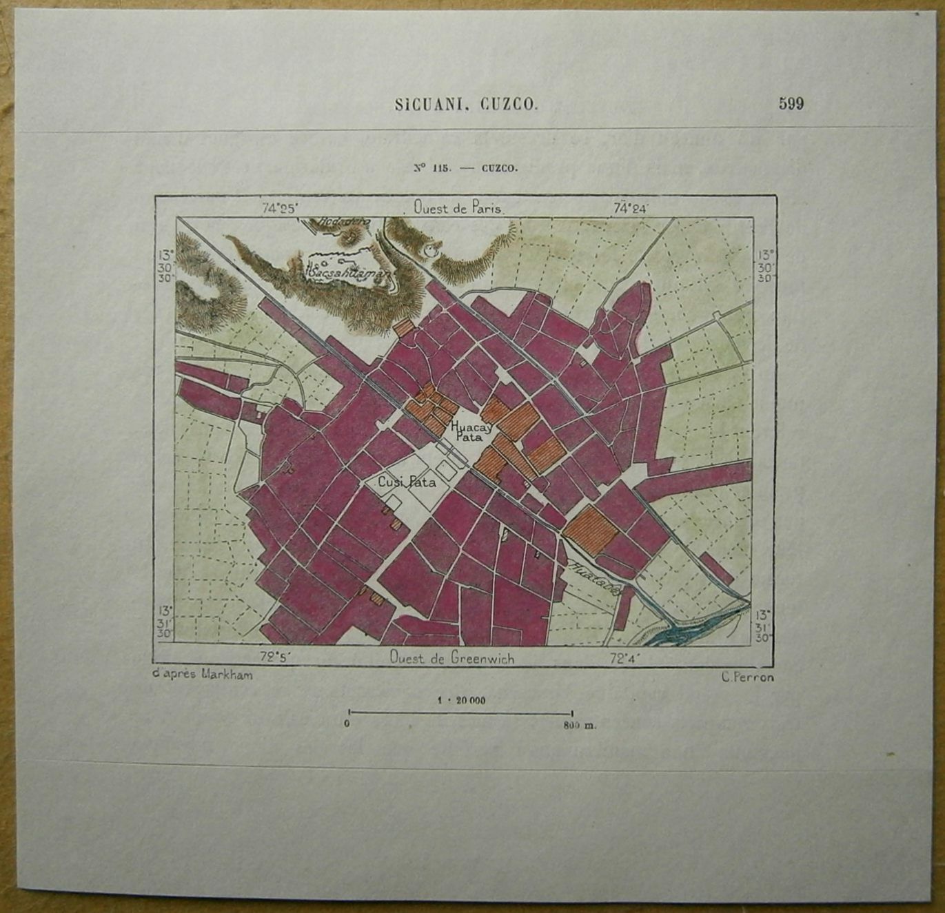
1893 Perron map CUZCO, PERU (#115)
$ 10.53
- Description
- Size Guide
Description
Perron18_1151893 Perron map CUZCO, PERU (#115)
Nice map titled
Cuzco,
from wood engraving with fine detail and clear impression, nice hand coloring. Overall size approx. 16.5 x 16 cm, image size approx. 10.5 x 8 cm. From
La Nouvelle Géographie universelle, la terre et les hommes
, 19 vol. (1875-94), great work of Elisee Reclus. Cartographer is Charles Perron.
Cuzco
also spelled Cusco, Kosko, or Qosqo,
city, capital of Cuzco provincia and Inca región, south-central Peru. Formerly the capital of the extensive Inca empire, it is one of the oldest continuously inhabited cities in the Western Hemisphere. It retains much of its highly crafted, early stone architecture, which is typically preserved in the foundations and lower stories of Spanish colonial structures. Cuzco was designated a UNESCO World Heritage site in 1983.
The city stands high in the Andes at an average elevation of 11,152 feet (3,399 metres) at the west end of Huatanay Valley, a basin extending 20 miles (30 km) east to Huambutio. It is watered by the small Huatanay, Huancaro, and Chunchullmayo rivers, tributaries of the Vilcanota. The air is generally dry, and frost is rare even during the coldest months, June and July. The rainy season is from November to February.
Cuzco, whose name derives from a Quechua word meaning “navel,” or “centre,” dates from the 11th or 12th century and was the capital of Tawantinsuyu (“Realm of the Four Parts”), an empire that by the late 15th century extended to the northwest some 1,100 miles (1,800 km), corresponding approximately to the northern border of present-day Ecuador, and to the south 1,600 miles (2,600 km), reaching the centre of present-day Chile, as well as to the southeast to portions of modern Bolivia and Argentina. The population of the empire at the time of the Spanish conquest, in the 1530s, may have numbered more than 12 million. The city itself had tens of thousands of inhabitants, and perhaps as many as 200,000. Cuzco and the surrounding area contain extensive Inca ruins that reflect great skill in engineering, stonework, and architecture. Still extant are numerous walls built without mortar; their stones were cut in irregular shapes and fitted with such precision that a matchbox cover cannot be inserted into most seams. The famous Stone of Twelve Angles is a fine example of this construction. The original streets of Cuzco are narrow and frequently stepped.
Francisco Pizarro's forces occupied Cuzco in November 1533 and sacked the city. Pizarro formally established the municipal government of Cuzco in March 1534 in the name of the emperor Charles V, but the city declined in importance after Pizarro moved his capital to the coastal site of Lima in 1535. A major earthquake occurred in 1650, causing great destruction to the buildings then standing in Cuzco. The rebuilding efforts that followed mark the beginning of the Cuzco Baroque period, during which the city was the centre of a prolific artistic production in masonry, painting, sculpture, jewelry, and ornamental woodworking. The work was guided or influenced by Roman Catholic priests and monks, and several notable churches and other buildings were erected in place of—or above—existing Inca structures.
The Church of Santo Domingo incorporates the foundations and several walls of the Koricancha (Coricancha), a Quechua name meaning “Golden Enclosure,” or “Golden Garden”; the site was also known as the Temple of the Sun. During Inca rule, the Koricancha's finely crafted walls were sheathed in hundreds of silver and gold plates, and its roof was covered with a mixture of thatch and gold “straws” so that it glittered in the sunlight. In its terraced gardens the Inca ruler ceremonially planted finely crafted gold statuettes in the form of stalks of corn (maize). According to some early chroniclers, the temple grounds also contained gold statues of llamas, shepherds, insects, flowers, and small animals. As with most other treasures of the Inca empire, however, the artwork of the Koricancha was shipped to Spain and converted into bullion. During the 1990s the municipal government funded archaeological excavations on land adjoining the Church of Santo Domingo (formerly the outer court of the temple), but there was controversy over proposed excavations of the building itself.
The cathedral was consecrated in 1654 on the site of the Inca palace of Viracocha (Huiracocha). Also significant architecturally are the National University of San Antonio Abad del Cuzco (founded 1598); the church of La Companía, which was built on the foundations of the Temple of the Serpents (Amarucancha); La Merced church and convent, the earliest Christian church in Cuzco (founded 1534); Santa Catalina convent, which replaced the House of the Virgins of the Sun (Acllahuasi); and a number of other ecclesiastical buildings. The house of the 16th-century historian Garcilaso de la Vega is also notable.
The cyclopean fortress of Sacsahuamán (Sacsayhuamán, or Saqsaywamán) overlooks the valley from a hill 755 feet (230 metres) above Cuzco. It is said that, in the Inca city plan, Cuzco itself represented the body of a puma (an animal sacred to the Inca), while Sacsahuamán formed its head and jaws. That image is reinforced by the zigzag outline of the fortress's massive three-tiered battlements, facing outward from the city. Many of its component stones are the size of boulders, weighing as much as 100–300 tons and measuring up to 27 feet (8.2 metres) in height. Sacsahuamán's walls extend horizontally more than 1,000 feet (305 metres). Defensive towers and other structures on the hill behind the walls were razed by Spanish forces. Sacsahuamán is said to have been constructed over a period of 80 years with a labour force of 20,000. Both the time of its construction and the method used to transport the stones are unknown. Facing the fortress across a wide parade ground is the so-called Throne of the Inca, a rounded mass of solid rock upon which were cut “seats” that were occupied, according to tradition, by Inca nobles during major ceremonies and celebrations. Other ruins nearby include the Inca bath, or Tambomachay (Tampumacchay); the Kenco amphitheatre; and the fortress of Puca Pucara. In May 1950 Cuzco was badly shaken by an earthquake that damaged all the churches and almost 90 percent of the dwellings.
In the environs of Cuzco, potatoes and grains are cultivated for local consumption, and sheep, alpaca, and llama are grazed. Important local industries are the production of cloth, rugs, tapestries, fine metalwork, and beer for both the local and tourist markets. The population is chiefly Indian and mestizo. The famous ruins of Machu Picchu are accessible by rail from the city, and roads link it with nearby Pisaq (famous for its weekly market and for its hilltop ruins), Ollantaytambo (a terraced fortress at the head of the Vilcanota valley), Urubamba (a favourite resort of the Inca), and the village of Chinchero. Cuzco is linked to Puno, Arequipa, and other southern cities by road and railway and is connected with Lima by road. Many foreign tourists and Peruvian travelers reach the city by air. Each June 24, Cuzco hosts Inti Raymi (“Festival of the Sun”), a grand celebration and pageant in commemoration of the ancient Inca religious festival of the solstice. Pop. (1993) 255,568.


