-40%
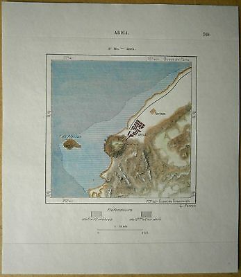
1893 Perron map ARICA, CHILE (#144)
$ 10.55
- Description
- Size Guide
Description
Perron18_1441893 Perron map ARICA, CHILE (#144)
Nice map titled
Arica,
from wood engraving with fine detail and clear impression, nice hand coloring. Overall size approx. 18.5 x 16 cm, image size approx. 9.5 x 9.5 cm. From
La Nouvelle Géographie universelle, la terre et les hommes
, 19 vol. (1875-94), great work of Elisee Reclus. Cartographer is Charles Perron.
Arica
,
capital of Arica province, Tarapacá region, Chile. The city lies along the Pacific coast, at the foot of El Morro (a precipitous headland), and is fringed on its southern edge by sand dunes of the rainless Atacama Desert. Arica is situated near the Peruvian border and is the northernmost Chilean seaport. Founded as San Marcos de Arica in 1570 on the site of a pre-Columbian settlement, it belonged to Peru until 1879, when it was captured by the Chileans, who gained control of the locality under the Treaty of Ancón (1883). The question of Chile's legal possession was not finally resolved until 1929.
Until the mid-20th century, Arica served as a free port and handled considerable Bolivian transit trade. It is still a free port for Bolivia and a commercial centre for Peru and northern Chile, and various industries, chiefly fish meal processing and automobile assembly, have developed in the city. It is the terminus of an oil pipeline from Oruro, Bolivia. The irrigated Azapa and Río Lluta valleys yield farm produce for Arica and olives and citrus fruit for export. With its seaport, international airport, railways to Tacna, Peru, and La Paz, Bolivia, and its location on the Pan-American Highway, Arica is a transportation hub. It is also a beach resort for Bolivian society. Pop. (1985 est.) 126,700.
