-40%
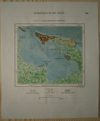
1891 Perron map SAN JUAN, PUERTO RICO (#174)
$ 10.53
- Description
- Size Guide
Description
Perron17_1741891 Perron map SAN JUAN, PUERTO RICO (#174)
Nice map titled
San-Juan Bautista de Puerto-Rico,
from wood engraving with fine detail and clear impression, nice hand coloring. Overall size approx. 17.5 x 16 cm, image size approx. 10 x 9 cm. From
La Nouvelle Géographie universelle, la terre et les hommes
, 19 vol. (1875-94), great work of Elisee Reclus. Cartographer is Charles Perron.
San Juan
capital and largest city of Puerto Rico, located on the northern coast of the island, on the Atlantic Ocean. A major port and tourist resort of the West Indies, it is the oldest city now under U.S. jurisdiction. Originally, the settlement was known as Puerto Rico and the island as San Juan, but common usage over the centuries brought about a reversal of the names. Pop. (2000) 426,618; San Juan–Caguas–Guaynabo Metro Area, 2,509,007; (2010) 381,931; San Juan–Caguas–Guaynabo Metro Area, 2,478,905.
In 1508 the Spanish explorer Juan Ponce de León founded the original settlement, Caparra, on the almost landlocked harbour just to the west of the present metropolitan area. In 1521 the settlement was moved to a rocky islet at the harbour entrance. Casa Blanca (“White House”) was begun that same year and was owned by Ponce de León's family until the late 18th century. In 1533 the Spanish began construction of massive fortifications in response to attacks by native Taino and by rival European powers. The bulwark-palace known as La Fortaleza, built near Casa Blanca, was the first of the new defenses (it now houses the governor's mansion). San Felipe del Morro castle (also called El Morro) was constructed next, on a high bluff overlooking San Juan Bay.
In the early 16th century San Juan was the point of departure for Spanish expeditions to unknown parts of the New World. Its fortifications repulsed the English navigator Sir Francis Drake in 1595 as well as later attackers, but George Clifford, 3rd earl of Cumberland, captured it briefly in 1598, and a Dutch force took the city from the landward side in 1625. In response, the fortress of San Cristóbal, the largest Spanish fort in the New World, was built to the northeast, and, from 1634 to 1638, walls were erected across the southern part of the city, facing the harbour. The bastions existing today were largely added during the period 1765–83. In May 1898 the guns of San Cristóbal engaged a U.S. fleet that bombarded the city. Puerto Rico became a U.S. territory under the terms of the Treaty of Paris that same year.
Ponce de León is buried in San Juan's cathedral, which was begun in 1521 and rebuilt in 1540 and again in 1802. San José Church, begun in 1532, is the oldest church in continuous use in the Western Hemisphere. La Casa del Callejón (“House of the Narrow Street”) includes museums of colonial architecture and of Puerto Rican family life. La Casa del Libro (1955; “House of the Book”) is a rare-book library and museum housed in an 18th-century structure. Ponce de León's Casa Blanca has been converted into a historical museum, and another 18th-century house has become a museum preserving the manuscripts, personal effects, and instruments of Spanish cellist Pablo Casals, who lived in Puerto Rico from 1956 to 1973. San Juan National Historic Site (1949) includes the El Morro and San Cristóbal fortifications; this area, along with La Fortaleza, was designated a UNESCO World Heritage site in 1983.
