-40%
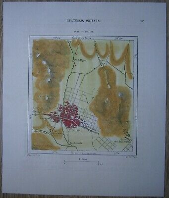
1891 Perron map ORIZABA, VERACRUZ, MEXICO (#43)
$ 11.08
- Description
- Size Guide
Description
Perron17_0431891 Perron map ORIZABA, VERACRUZ, MEXICO (#43)
Nice small map titled
Orizaba,
from wood engraving with fine detail and clear impression, nice hand coloring. Overall size approx. 19.5 x 16.5 cm, image size approx. 12 x 11 cm. From
La Nouvelle Géographie universelle, la terre et les hommes
, 19 vol. (1875-94), great work of Elisee Reclus. Cartographer is Charles Perron.
Orizaba
city, west-central Veracruz estado (state), east-central Mexico. It lies in a fertile, well-drained, and temperate valley of the Sierra Madre Oriental, over which towers Citlaltépetl (also called Pico de Orizaba), a snowcapped volcano. The town was founded by Spaniards in the 16th century on the former site of an Aztec garrison called Ahuaializapan (“Pleasant Waters”) to guard strategic routes linking the port of Veracruz and Mexico City. Chartered as a city in 1774, Orizaba was licensed under crown monopoly to produce tobacco and was one of the first Mexican textile centres. Its public buildings reflect its long colonial past. It is an agricultural centre (producing tobacco, corn [maize], sugarcane, and cereals), an industrial centre, and a tourist resort. It is accessible by highway and railroad. In August 1973 a severe earthquake, centred near the city, caused many deaths and widespread destruction. Pop. (2000) 118,552; metro. area, 367,021; (2010) 120,844; metro. area, 410,508.


