-40%
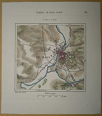
1877 Perron map LE MANS, FRANCE (#158)
$ 10.53
- Description
- Size Guide
Description
Perron02_1581877 Perron map LE MANS, FRANCE (#158)
Nice small map titled
Le Mans
, from wood engraving with fine detail and clear impression, nice hand coloring. Overall size approx. 18 x 16 cm, image size approx. 11 x 10.5 cm. From
La Nouvelle Géographie universelle, la terre et les hommes
, 19 vol. (1875-94), great work of Elisee Reclus. Cartographer is Charles Perron.
Le Mans
town, capital of Sarthe département, Pays de la Loire région, northwestern France. Situated in the former province of Maine, the town lies southwest of Chartres at the confluence of the Sarthe and Huisne rivers.
Le Mans derives its name from the ancient Gallic tribe of the Cenomani, whose capital it was. In the late 3rd century AD the Gallo-Romans surrounded the town with walls, parts of which still survive. Also in the 3rd century, St. Julien evangelized the city and established a bishopric there. After the 6th century Le Mans became the seat of the counts of Maine. In the early 12th century the countship passed to the Plantagenets, counts of Anjou. Henry II, the first Plantagenet king of England, was born in Le Mans in 1133. Le Mans reverted to the French crown in the 13th century. The English invaded it during the Hundred Years' War between England and France (1337–1453). Royalists and republicans successively took over the town during the French Revolution.
The old city, which is mainly cramped within the old Gallo-Roman walls on the left bank of the Sarthe, contrasts strikingly with the new town, which surrounds it.
Saint-Julien Cathedral (11th–15th century), which towers over the old city, combines Romanesque and Gothic styles. On the right side there is a beautifully sculptured 12th-century portal and, at the end of the transept, a 12th–15th-century tower 210 feet (64 m) high. The choir (13th century), which is one of the tallest and handsomest in France, is exteriorly supported by buttresses of an exceptionally light and elegant design. The cathedral features magnificent 13th-century stained-glass windows and two fine Renaissance tombs. The Church of Notre-Dame-de-la-Couture (10th–13th century) possesses a Gothic facade with remarkable 13th-century sculptures. The Church of Sainte-Jeanne-d'Arc, which was founded by Henry II of England (reigned 1154–89), is also of interest. The picturesque old town has a number of Renaissance and 17th-century houses.
Le Mans was mainly a market town for the agricultural products of the region until the mid-19th century, when new industries developed and later expanded, principally producing railway, motorcar, and agricultural machinery; textiles; and tobacco. More recently, the plastics and electrical-machinery industries have been added, as well as a growing service sector, especially the insurance industry.
Every year the Le Mans Grand Prix d'Endurance, probably the world's best-known automobile race, is held at the Sarthe road-racing circuit just outside the town. Nearby there is a museum of early motorcars. Pop. (1990 prelim.) 146,000.


