-40%
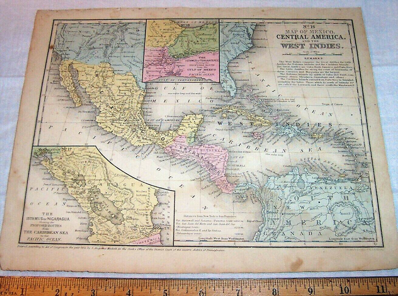
1852 Mexico West Indies & Central America Antique Map ; Cuba Caribbean Islands
$ 23.76
- Description
- Size Guide
Description
Antique Hand-colored MapMexico
Central America
West Indies
8" x 10.5" at the borders.
About 9" x 11.5" overall.
Mitchell's Geography Map
Engraved by J. H. Young
Copyright
1852
168 Years Old
Mexico , Central America , and the West Indies as they were in the middle of the 19th century.
With smaller inset maps showing proposed routes for
canals
through Central America , connecting the Atlantic and Pacific Oceans.
I. The
Isthmus of Tehuantepec
showing the
Proposed Route
from the Gulf Of Mexico to the Pacific Ocean.
Including
Tabasco , Mount Tecuanapa , Vera Cruz , Proposed Railroad 170 Miles , Sierra Madra Mountains , Minatitlan , etc., etc.
II. The
Isthmus of Nicaragua
showing the
Proposed Routes
from the Caribbean Sea to the Pacific Ocean.
Including
Lake Nicaragua , Woolwa Indians , Mosquito Shore , Fort San Carlos , Guanapepe Volcano , Rama Indians , Orosi Volcano , Proposed Canal(s) , Proposed Railroad , Volcano of Masaya , Momabacho Volcano , Ometepec Volcano , Cookra Indians , Sierra Madre , etc., etc.
Also gives Distances from
New York to San Francisco
by the proposed routes.
Map maker
Samuel Augustus Mitchell
( born 1790 at Bristol, Connecticut – died December 20, 1868 at Philadelphia ) was an American geographer.
Condition
Some soiling and staining, some wear at the margin edges.
Some old pencil doodling, including names " Louis Fowler " and " Fanny E. Niles ," and a traced hand labelled " 9 yeras old."
Otherwise good.
A
Sampling
of
Features on the Map
includes:
American Indians in the Southwest ( United States ) including
Comanches in Texas and Apaches in Arizona / New Mexico
Tampa , Florida
Key West , Florida
Dry Tortugas
Colorado River
Los Angeles ( California )
Rio Grande River
Pikes Peak ( Colorado )
Laredo ( Texas )
Mexico
Old California ( Mexico )
Chihuahua
Durango
Monterey , 1846
Buena Vista , 1847
( two battles of the Mexican - American War )
Sonora & Sinaloa
Guadalaxara
Vera Cruz
Oaxaca
Mexico ( City )
Yucatan
Balize ( Belize )
Bay of Honduras
Guatimala
Honduras
Water Volcano
Volcano of Isalco ( Izalco )
Volcano of Coseguina ( Cosiguina )
San Salvador
Costa Rica
Panama
Railroad ( Panama )
Gulf of Darien
Andes Mountains
Bogota ( Colombia , South America )
Orinoco River
Venezuela
Bolivar City
Rio Negro
Carthagena
Bahama Islands
Guanahani or Cat Island - " the first land discovered by Columbus in 1492 "
Cuba
Havana
Jamaica
Isle of Pines ( Isla de la Juventud )
Grand Cayman
Hayti
Dominica
Porto Rico
Caribbean Sea
Caribbee Islands
Little Antilles
Trinidad
Barbadoes
Etc., Etc.
Carefully Packed for Shipment to the Buyer
Have a Look at my Many Other Items


