-40%
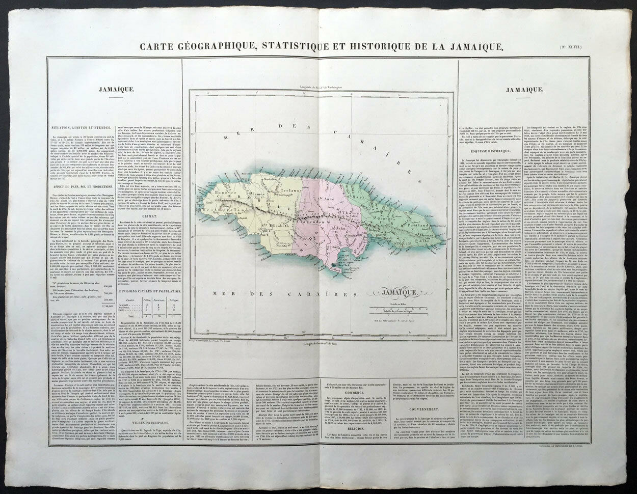
1825 Buchon - Carey, Lea - Large Antique Map of The Island of Jamaica Caribbean
$ 92.4
- Description
- Size Guide
Description
ebay profile//ebay store
Carte Geographique, Statistique et Historique De La Jamaique
Cartographer :
- Buchon, Jean Alexandre 1791 – 1849
Date:
- 1825
Size:
- 27 1/2in x 21 1/2in (700mm x 545mm)
Ref#:
- 70025
Condition:
- (A+) Fine Condition
Description:
This large beautifully hand coloured original 1825 antique map was published by Jean Alexandre Buchon in the French edition of Carey & Lea's 1822 atlas
A Complete Historical, Chronological, and Geographical American Atlas
.
This map is in exceptionally fine condition, on clean, sturdy and stable heavy paper, heavy engraving and beautiful original hand colour.
In 1822, Henry Charles Carey and Isaac Lea published their American Atlas. The atlas was based on Emmanuel Las Cases' Atlas Historique of 1803, with updated maps and text modified by Carey, a political economist.
He considered himself an American foil to John Stuart Mill and the London economists who were proclaimers of "the gloomy science" influenced by Ricardo and Malthus. Instead of preaching overpopulation and degeneration of the human species, Carey illustrated the nations of the western hemisphere through maps that showed an expanding region with ample promise of developing into lands of great new opportunity and growth. The sheets from this atlas, which cover North America, Central America, South America and the West Indies, are comprised of an engraved map surrounded by text documenting the history, climate, population and so forth of the area depicted. The atlas is particularly known for its excellent early maps of the states and territories of the United States. Many of these maps were drawn by Fielding Lucas, Jr., an important Baltimore cartographer. All of the maps show excellent and very up-to-date detail, providing fine verbal and graphic pictures of states and territories in the early 19th century (Ref: M&B; Tooley)
General Definitions:
Paper thickness and quality: - Heavy and stable
Paper color : - off white
Age of map color: - Original
Colors used: - Yellow, green, blue, pink
General color appearance: - Authentic
Paper size: - 27 1/2in x 21 1/2in (700mm x 545mm)
Plate size: - 27 1/2in x 21 1/2in (700mm x 545mm)
Margins: - Min 1in (25mm)
Imperfections:
Margins: - None
Plate area: - None
Verso: - None
Background:
A Complete Historical, Chronological, and Geographical American Atlas, being A Guide to the History of North and South America, and the West Indies: exhibiting an Accurate Account of the Discovery, Settlement, and Progress of their Various Kingdoms, States, Provinces, &c. together with the Wars, Celebrated Battles, and Remarkable Events, to the Year 1822.
At the time of publication this was the best and most detailed atlas to be produced in the United States. Fielding Lucas, the major Baltimore printer, was the principal engraver and substantial historical background text accompanies each map. Among the most noted maps in the atlas is Major Stephen H. Long's "Map of Arkansa and other Territories of the United States." That map, which depicts the Missouri basin between Nashville in the east, the Mandan villages in the north and the Rocky Mountains in the west, was based on the surveys conducted by Long on his expeditions of 1819 and 1820. The map published in Carey & Lea's atlas preceded the official account of that expedition by expedition botanist Edwin James, which included a smaller map with similar detail (titled "Country drained by the Mississippi Western Section"). Carey and Lea's 1823 publication of James Account perhaps explains the prior inclusion of this map with Long expedition information in their atlas. On this famous map is the printed legend, which would perpetuate a myth for many years to come, identifying the high plains as the "Great American Desert." Carey and Lea's atlas was first issued, as here, in 1822; an 1823 second issue followed, substantially the same as the first but with a new title and revised states of several maps and text leaves (generally minor revisions, including additional shading to maps and resetting of several text leaves).
The firm of Carey, Lea & Blanchard
(referred to here, for convenience, as Carey & Lea), the successor to the prominent publishing house of Matthew Carey & Co., was formed in 1833 with the appointment of William Blanchard as partner. The firm was already well established, and under the helm of its founder, Matthew Carey, had made publishing history since its founding in 1785. Matthew Carey began as publisher of the Pennsylvania Evening Herald that year, but soon left the newspaper to found his publishing enterprise. His young son Henry, (who later added a middle name, Charles, in memory of a brother who died as an infant), born 1792, was working in the business very early. By age twelve, Henry was managing his father's branch store at 229 Market Street, and by fifteen he was managing the finances of the firm. In 1817 he was elevated to junior partner and the company's name was changed to Carey & Son. In 1822, after marrying Matthew Carey's daughter, Frances Anne, Isaac Lea, was brought in as junior partner. He was a member of the Academy of Natural Sciences of Philadelphia, and, despite his work at the company, would continue pursuing his scientific studies in geology. The firm was now called Matthew Carey & Sons. Matthew Carey retired, his share bought out by Henry, in 1824. However, his influence would remain strong until his death in 1839. Likewise, the company would continue paying him a handsome salary, and some of his incidental expenses.
Henry's younger brother, Edward Carey, who had been working in publishing in England since 1822, joined the firm in 1827. He left in 1829, but during his brief stay the company was known as Carey, Lea & Carey. He joined in a publishing partnership with Abraham Hart. With his departure, Carey & Lea was formed.
In 1833, William A. Blanchard was named partner, and the firm was renamed Carey, Lea & Blanchard. William Blanchard had joined the firm in 1812. One account says that "no partner could have been more silent than Blanchard. A faithful and unobtrusive employee before, he remained equally obscure as a partner, and presumably took no creative part in publishing policy." However, Blanchard seems to have had a strong influence on the day-to-day operations of the firm, because the other principals took more time, once Blanchard was minding the home office, to work on their own writing efforts.
Henry Carey decided to retire from book publishing in 1838. With his departure, the firm was renamed to Lea & Blanchard. Carey's outside interests included political economy, and he had begun the three-year processing of publishing his three-volume Principles of Political Economy in 1837. He went on to write Past, Present and Future in 1848, Principles of Social Science, published between 1858 and 1860, and The Unity of Law in 1872. The Principles of Social Science was widely translated and reprinted. Politically, Henry Carey was aligned with his father, a staunch nationalist and economic protectionist in the 1840's. He helped organize the Republican Party in 1856, and died in 1879.
Isaac Lea, too, had a rich life outside the company, and after his retirement from Lea & Blanchard in 1851, he devoted himself to his beloved geology and passed his interest in the publishing firm to his son, Henry Charles Lea. Isaac Lea continued publishing geological studies into the 1880's, dying in 1886.
Henry Charles Carey
1793 – 1879 Carey was a leading 19th-century economist of the American School of capitalism, and chief economic adviser to U.S. President Abraham Lincoln.
Carey is best known for the book The Harmony of Interests: Agricultural, Manufacturing, and Commercial (1851), which denigrates the "British System" of laissez faire free trade capitalism in comparison to the American System of developmental capitalism, which uses tariff protection and government intervention to encourage production and national self-sufficiency.
Born in Philadelphia, Pennsylvania in 1793, Carey was the son of Mathew Carey (1760–1839), an influential economist, political reformer, editor, and publisher. Mathew Carey was born in Dublin, Ireland but emigrated to Philadelphia in 1784, where with the help of Benjamin Franklin and the Marquis de Lafayette he founded a publishing firm. Among his many writings was Essays on Political Economy (1822), one of the earliest American treatises favoring Alexander Hamilton's idea of protection and its use in the promotion of American industry.
In 1825, Carey succeeded his father in the publishing firm, which became Carey & Lea, attaining a leading position in America. In 1835, Carey co-founded the famous Franklin Fire Insurance Company of Philadelphia.
Carey retired from business in 1838 while publishing his 4-volume treatise (1837–1840) Principles of Political Economy, which soon became the standard representation of the American school of economic thought, and was translated into Italian and Swedish, with some variance, dominating the U.S. economic system until 1973.
In 1863, Carey was elected an Associate Fellow of the American Academy of Arts and Sciences, and in 1868, a foreign member of the Royal Swedish Academy of Sciences.
Isaac Lea
1792 – 1886 was an American conchologist, geologist, and publisher, who was born in Wilmington, Delaware
Mathew Carey retired in 1825, leaving his prosperous business in the hands of his son Henry Charles Carey and son-in-law Isaac Lea. The publishing house became one of the most successful in America, publishing among others The Encyclopedia Americana, a dictionary of German lexicon, as well as American editions of the works of Walter Scottand James Fenimore Cooper. The firm promoted William A. Blanchard to partner in 1833, and when Mathew Carey died in 1838 and Henry Carey retired in 1846, the publishing house's name changed to Lea & Blanchard, and it became Lea Brothers when his sons entered into the business and Isaac himself retired to pursue his scientific interests. In the 1840s, the Careys were staunch nationalists and economic protectionists.
Buchon, Jean Alexandre 1791 – 1849
Buchon was a French scholar born at Menetou-Salon.
Buchon was an ardent Liberal and took an active part in party struggles under the Restoration, while throwing himself into the historical regeneration then taking place.
During 1822 and the succeeding years he travelled about Europe in search of materials for his Collection des chroniques nationales françaises écrites en langue vulgaire, du XIe au XVIe siècle (4 vols, 1824–1829).
After the revolution of 1830 he founded the Pantheon littéraire, in which he published a Choix d'ouvrages mystiques (1843), a Choix de monuments primitifs de l'église chrêtienne (1837), a Choix des historiens grecs (1837), a collection of Chroniques trangres relatives aux expeditions françaises pendant le XIII siècle (1840), and, most important of all, a Choix de chroniques et mémoires sur l'histoire de France (1836–1841).
What is an Antique Map
The word Antique in the traditional sense refers to an item that is more than a hundred years old. In the past maps were sold in two forms, as a single sheet (broadsheet) or bound in an atlas or book. The majority of antique maps for sale today come from books or atlases and have survived due to the protection offered by the hardback covers.
When considering a purchase
The first thing to determine when staring a collection or purchasing an item, is what is important to you. Most collectors prefer to build their collections around a theme. You may decide to collect maps from one region or country, charting its development through time. Similarly you could collect maps of one particular period in time, by type (i.e. sea or celestial charts) or by cartographer. The collector might also want to consider the theme of cartographical misconceptions such as California as an island or Australia as Terra Australis or the Great Southern Land.
The subject is so wide that any would-be-collector has almost endless possibilities to find his own little niche within the field, and thereby build a rewarding collection.
Starting a collection & pricing
Pricing is based on a number of different factors, the most important of which is regional. In any series of maps the most valuable are usually the World Map and the America/North America. The World because it is usually the most decorative and America because it has the strongest regional market. Other factors that come into play re: price is rarity, age, size, historical importance, decorative value (colour) and overall condition and quality of paper it is printed on.
As specialised dealers, we frequently work with first time map buyers who are just starting their collection. Guiding new collectors on their first antique map purchase and helping new collectors to focus their interests is one of the most rewarding aspects of being an rare map dealer. So please do not hesitate to and we will be happy to help with any questions you may have.
Payment, Shipping & Return Options
Please click on the "Shipping and Payments" Tab above for shipping, payment and return details
About US
Classical Images was founded 1998 and has built an excellent reputation for supplying high quality original antiquarian maps, historical atlases, antique books and prints. We carry an extensive inventory of antiquarian collectibles from the 15th to 19th century. Our collection typically includes rare books and decorative antique maps and prints by renowned cartographers, authors and engravers. Specific items not listed may be sourced on request.
Classical Images adheres to the Codes of Ethics outlined by the Antiquarian Booksellers Association of America (ABAA).
We are a primarily an online based enterprise, however our inventory may be viewed by appointment. Please call or email to arrange a viewing.
Track Page Views With
Auctiva's FREE Counter


