-40%
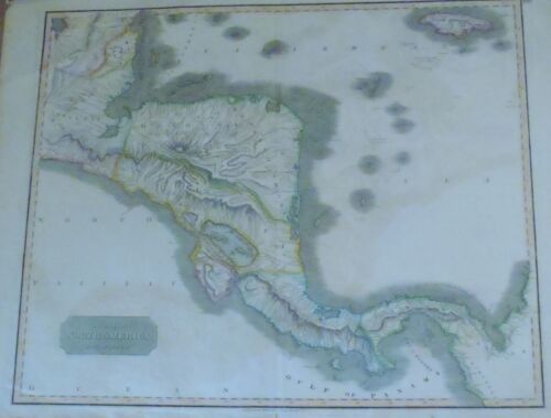
1816 CENTRAL AMERICA for Thomson's New General Atlas #59 COLOR COPPERPLATE MAP
$ 89.49
- Description
- Size Guide
Description
1816 CENTRAL AMERICA for Thomson's New General Atlas #59 COLOR COPPERPLATE MAP1816 CENTRAL AMERICA for Thomson's New General Atlas #59 COLOR COPPERPLATE MAP
POB#55244
TITLE:
Spanish North America, southern part. Drawn & engraved for Thomson's New general atlas, 1816.
MAPMAKER:
John Thomson
ENGRAVER:
John Moffat
PUBLISHER:
London, Edinburgh, & Dublin: Baldwin, Cradock, and Joy; John Cumming; John Thomson
DATE:
1816 (on map); Atlas first published in 1817, with later editions to follow.
EDITION:
Drawn & engraved for Thomson's New general atlas, 1817
.
FORMAT:
Folio atlas biofolium.
SIZE: Height
51 cm
SIZE:
Width 61 cm.
.
FEATURES:
Relief shown by hachures. Covers areas of New Spain now currently known as Guatemala, Nicaragua, Honduras, El Salvador, Costa Rica, and Panama. Parts of Mexico and Belize in north, and part of Columbia in south. The political boundaries shown in color.
.
The map reflects part of a tumultuous period of independence struggles in all of Spanish America, and especially Central America, following the American Revolution. The boundaries and province names shown will be short-lived after publication and will vary in later editions.
.
AUTHENTICATION & REFERENCE: Not a reproduction! Actually printed as noted above.
Catalog of Maps of Hispanic America Volume 3, page 75
.
CONDITION NOTES:
VERY GOOD. Removed from atlas with original bindery stub neatly affixed to back. Will arrive folded. Light damp stain. No offsetting. Light soiling and minor edge faults to top edge. A small crease tear at bottom of fold.
Listing and template services provided by inkFrog


