-40%
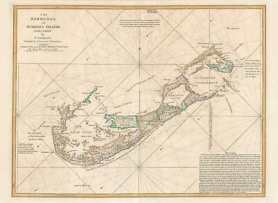
1794 Lempiere Map of Bermuda
$ 1393.91
- Description
- Size Guide
Description
1794 Lempiere Map of BermudaWE SELL ONLY ORIGINAL ANTIQUE MAPS - NOT REPRODUCTIONS
Title:
The Bermudas, or Summer's Islands from a Survey by C. Lempriere, regulated by Astronomical Observations.
Description:
This is the first commercial sea chart an map of Bermuda to incorporate data from Clement Lemprière's important survey of 1738. The map covers all of Bermuda and some of the adjacent seas. Crosses at sea illustrate the locations of shoals and reefs. The map features detailed topography, noting roads, nautical routes around the island, settlements, and more. Administrative districts, or 'Tribes' are identified throughout. In the lower right in a long block text of considerable value to the mariner.
Bermuda, a haven for smugglers
Lemprière was probably contracted by the governor of Bermuda to survey the island in an attempt to curb smuggling. By the 18th century Bermuda had become a mecca for smugglers. The small archipelago was conveniently located on the trade route between the West Indies and Europe. Free traders, pirates, and smugglers from all countries could conceal themselves in any of Bermuda's many hidden coves and bays and conduct trade without pay the East India Company tax. They could also use the hidden coves to trade with foreign nations under British embargo. The colonial governors tried in vain to stop the rampant smuggling, but with only a small military staff and a host of corrupt official, the effort proved hopeless.
The Tribes of Bermuda
The Somers Isles company was founded by the shareholders of the Virginia Company formed in 1614. When the Virginia company folded in 1622, Somers Isles Company, with a separate charter, continued to administer Bermuda foe nearly six decades. Most of Bermuda was subdivided into eight equally sized administrative zones initially termed 'tribes,' later changed to 'parishes'. These were named for shareholders in the Company, and were further divided (by tribe roads) into lots equating to shares held. Saint George formed a ninth subdivision, now the eastern-most parish, incorporating Saint George's Island, Saint David's Island, part of the Main Island, and various smaller islands and islets around Castle Harbour (then known as Southampton Harbour) and Saint George's Harbour. This area was held in common by the Company shareholders and served as Bermuda's original capital, Saint George's Town. While Saint George Harbour was easily accessed by maritime merchants, the location of the capital made it difficult to administer the western part of the island, where smugglers and pirates were most active.
Publication History and Census
The cartography here, as previously noted, dates to Clement Lemprière's important survey, the first modern survey of the archipelago and is considerable advancement upon the Richard Norwood's 1662 survey. It is unclear of the exact dates when Lemprière conducted his Bermuda survey, but it was most likely in the early 1720s. Lemprière's own map was engraved by Toms and published in 1738, but is today near unobtainable. In 1775 Robert Sayer engraved the first state of this map, the plate for which subsequently was acquired by the firm of Laurie and Whittle. Due to the accuracy of Lemprière's survey, and dearth of new information, this map was published in nautical atlas and issued separately until 1829. Examples are scarce to the market.
Size:
Printed area measures 19 inches high by 26 inches wide.
Condition:
Very good. Light toning. Old color. Verso centerfold reinforcement.
Shipping:
Shipping rates are not negotiable. Items are shipped within three business days of receiving payment. We are happy to consolidate shipping where possible. The following shipping options are available:
1. FedEx Overnight (45 USD). USA Only. Signature Required.
2. FedEx Ground or Home Delivery (15 USD). USA Only. 1 - 10 days. If your address is a P.O. Box and cannot ship FedEx we will ship USPS Priority and, while we ship promptly, recent postal personnel cutbacks mean that delivery may take time. Signature Required.
3. FedEx International or DHL International EXPRESS (45 USD).
4. We can use your FedEx Account.
Customs:
International buyers are responsible for paying duty and taxes on delivery. DHL or FedEx will contact the buyer by telephone to arrange tax payment if it is levied. Duty varies by country and we cannot predict the amount you will be charged. Some countries are duty free, others are not. Typically, a customs duty and/or VAT tax will be assessed on all parcels to continental Europe. Sometimes duty or tax is due in China, but is seems very random. Hong Kong, Singapore, Korea, and Taiwan have never assessed duty on a map we shipped. Maps shipped to the UK should be duty free as educational materials, but from time to time duty of 5% is assessed incorrectly by the UK customs agents.
Insurance:
All shipments are insured privately against loss and damage. All of our shipments require a signature for insurance purposes.
If you have any questions please feel free to email us through eBay.
Other Services
Conservation Framing:
Geographicus recommends basic conservation framing services for any antique paper. We do not offer this service.
Antique Map Restoration:
Geographicus can repair and restore your antique map. Services include deacidification cleaning flattening and backing.
BEWARE anyone attempting to contact you, from a different eBay account, claiming to represent Geographicus Antique Maps. My eBay handle is GeographicusMaps. If you are contacted by email by someone offering you my items, please call me directly to be certain you are not dealing with a con artist.
"


