-40%
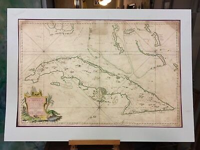
1762 Depot des Cartes Carte Reduite de l'Isle de Cube Map of Cuba Hydrographical
$ 792
- Description
- Size Guide
Description
PLEASE be sure to review ourReturn Policy
before making your purchase. Please let us know if you have any questions. All items are sold as described, photographed and as is.
1762 Map of Cuba and the Florida Keys with Hydrographic Details. Including
inlets, soundings, anchorages, routes of navigation, shoals and navigational hazards. Originally a folded piece. Also reproduced in 1973 as a postage stamp.
24.5' x 36"
"Carte Reduite de l'Isle de Cube Dressee au Depot des Cartes et Plans de la Marine, pour le Service des Vaisseaux du Roy par Ordre de Mle. Duc de Choiseul…", Bellin, Jacques Nicolas.
Very Good Antique Condition. There are a few professional, older repairs as shown. The edges bear some bumps and there is discoration as expected with age . See Photos For Details. Sold As Is/As Shown. This can be rolled between sheets of tissue loosely (10"-12" diameter) for less expensive shipping.
Visit:
www.stores.ebay.com/jackedwardscollection
for more great items like this!
Returns are accepted if an item is NOT as described or broken in transit. Buyer must request insurance to be added if desired. Returned items must arrive to us in the same condition as shipped and/or received to constitute a refund. Return shipping will be paid by buyer.
Returns are only accepted under the following criteria:
Buyer must contact us directly within
three
business days.
Item must be returned within
14
calendar days.


